Global CityIntelligence

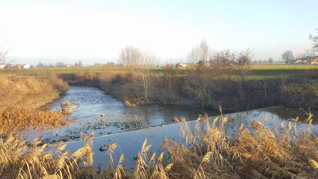
Verified Wikimedia Commons image of Trebbia River
Trebbia Riverabout 3 km (2 mi) from Piacenza. Image credit: Image: Sidvics / Wikimedia Commons, CC BY-SA 3.0

Nature discovery

Nature Near Piacenza, Italy

Research 18 classified outdoor destinations within weekend reach of Piacenza, grouped across 7 kinds of place and ordered by measured straight-line distance from the city centre. Distances only — no travel times, schedules, or rankings.

Places listed
18
Closest
Trebbia River — about 3 km
Furthest listed
about 100 km
Last updated
2026-05-16
Data year
2025

How this list is built

Each place is classified from its own Wikidata type, not from its name, and is ordered by measured straight-line distance from the centre of Piacenza. Distances are great-circle kilometres between two published coordinates — this page does not publish travel times, transport schedules, opening hours, ticket prices, or rankings. Confirm access, facilities, and seasonal conditions with an official source before travelling.

How far these are

Reachability is a second axis over the same places: the category says what a destination is, the band says how far it sits from Piacenza. Distances are measured in a straight line — this page publishes no travel times.

  • 7nearby
  • 11day-trip distance

What is out there

  • 5forests
  • 5waterfalls
  • 4mountains
  • 2protected areas
  • 2rivers
  • 1national park
  • 1park

18 places near Piacenza

Ordered by straight-line distance from Piacenza, closest first. Distance bands: nearby is up to 60 km, day-trip distance is up to 120 km.

Places near Piacenza

Showing all 18 places.

  • Verified Wikimedia Commons image of Trebbia River
    RiverNearby

    Trebbia River

    Straight-line distance
    about 3 km (2 mi)
    Recorded type
    river

    Trebbia River is Apennine river and protected river valley flowing into the Po just west of Piacenza; gravel braided riverbed with a regional river park. Research access, facilities, and seasonal conditions with official sources before visiting.

    View place Trebbia River, about 3 km (2 mi) from Piacenza

    Image credit: Image: Sidvics / Wikimedia Commons, CC BY-SA 3.0

  • Verified Wikimedia Commons image of Stirone River
    RiverNearby

    Stirone River

    Straight-line distance
    about 41 km (26 mi)
    Recorded type
    creek

    Stirone River is River forming part of the Piacenza-Parma boundary; centerpiece of the Stirone and Piacenziano regional park with fossil-bearing badlands, southeast of Piacenza. Research access, facilities, and seasonal conditions with official sources before visiting.

    View place Stirone River, about 41 km (26 mi) from Piacenza

    Image credit: Image: Cncerri / Wikimedia Commons, CC BY-SA 4.0

  • Verified Wikimedia Commons image of Monte Lesima
    MountainNearby

    Monte Lesima

    Straight-line distance
    about 54 km (33 mi)
    Recorded type
    mountain

    Monte Lesima is Ligurian Apennine peak on the Pavia-Piacenza provincial border southwest of Piacenza, between Trebbia tributaries. Research access, facilities, and seasonal conditions with official sources before visiting.

    View place Monte Lesima, about 54 km (33 mi) from Piacenza

    Image credit: Image: GrazianoU / Wikimedia Commons, CC BY 3.0

  • Verified Wikimedia Commons image of Monte Alfeo
    MountainNearby

    Monte Alfeo

    Straight-line distance
    about 58 km (36 mi)
    Recorded type
    mountain

    Monte Alfeo is forested pyramid-shaped peak of the Monte Antola group above the Val Trebbia, in Ottone, province of Piacenza, south of the city. Research access, facilities, and seasonal conditions with official sources before visiting.

    View place Monte Alfeo, about 58 km (36 mi) from Piacenza

    Image credit: Image: Sidvics / Wikimedia Commons, CC BY-SA 3.0

  • Verified Wikimedia Commons image of Monte Maggiorasca
    MountainNearby

    Monte Maggiorasca

    Straight-line distance
    about 58 km (36 mi)
    Recorded type
    mountain

    Monte Maggiorasca is highest peak of the Ligurian Apennines on the Liguria-Emilia-Romagna border south of Piacenza, in the Aveto area. Research access, facilities, and seasonal conditions with official sources before visiting.

    View place Monte Maggiorasca, about 58 km (36 mi) from Piacenza

    Image credit: Image: The original uploader was Franco.luigi.mazza at Italian Wikipedia. / Wikimedia Commons, CC BY-SA 3.0

  • Verified Wikimedia Commons image of Bosco Villoresi
    ForestDay-trip distance

    Bosco Villoresi

    Straight-line distance
    about 63 km (39 mi)
    Recorded type
    forest

    Bosco Villoresi is a forest reachable from Piacenza as a nearby nature destination. Research access, facilities, and seasonal conditions with official sources before visiting.

    View place Bosco Villoresi, about 63 km (39 mi) from Piacenza

    Image credit: Image: Lele monzani / Wikimedia Commons, CC BY-SA 3.0

  • Verified Wikimedia Commons image of Monte Penna
    MountainDay-trip distance

    Monte Penna

    Straight-line distance
    about 65 km (41 mi)
    Recorded type
    mountain

    Monte Penna is rocky peak on the Liguria-Emilia border within the Aveto regional park, source area of the Taro and Ceno rivers, south of Piacenza. Research access, facilities, and seasonal conditions with official sources before visiting.

    View place Monte Penna, about 65 km (41 mi) from Piacenza

    Image credit: Image: The original uploader was Vengomatto at Italian Wikipedia. / Wikimedia Commons, CC BY-SA 3.0

  • Verified Wikimedia Commons image of Antola Natural Regional Park
    Protected areaDay-trip distance

    Antola Natural Regional Park

    Straight-line distance
    about 80 km (49 mi)
    Recorded type
    protected area

    Antola Natural Regional Park is Regional nature park on the Trebbia-Scrivia divide centered on Monte Antola, southwest of Piacenza in the Genoa hinterland. Research access, facilities, and seasonal conditions with official sources before visiting.

    View place Antola Natural Regional Park, about 80 km (49 mi) from Piacenza

    Image credit: Image: The original uploader was G80 at Italian Wikipedia. / Wikimedia Commons, CC BY-SA 3.0

  • Verified Wikimedia Commons image of Appennino Tosco-Emiliano National Park
    National parkDay-trip distance

    Appennino Tosco-Emiliano National Park

    Straight-line distance
    about 92 km (57 mi)
    Recorded type
    national park

    Appennino Tosco-Emiliano National Park is National park along the Apennine ridge separating Emilia from Tuscany, with peaks over , lakes and beech forests, southeast of Piacenza. Research access, facilities, and seasonal conditions with official sources before visiting.

    View place Appennino Tosco-Emiliano National Park, about 92 km (57 mi) from Piacenza

    Image credit: Image: Emav71 at Italian Wikipedia / Wikimedia Commons, CC BY-SA 3.0

  • Verified Wikimedia Commons image of Chengen Falls
    WaterfallDay-trip distance

    Chengen Falls

    Straight-line distance
    about 98 km (61 mi)
    Recorded type
    waterfall

    Chengen Falls is a waterfall reachable from Piacenza as a nearby nature destination. Research access, facilities, and seasonal conditions with official sources before visiting.

    View place Chengen Falls, about 98 km (61 mi) from Piacenza

    Image credit: Image: Kaitu / Wikimedia Commons, CC BY-SA 4.0