Composite profile
Overall score
82/100
Read Perth as an isolated but high-amenity coastal capital where service quality and outdoor amenity balance housing pressure and drought-resilience priorities.
Australia / Oceania
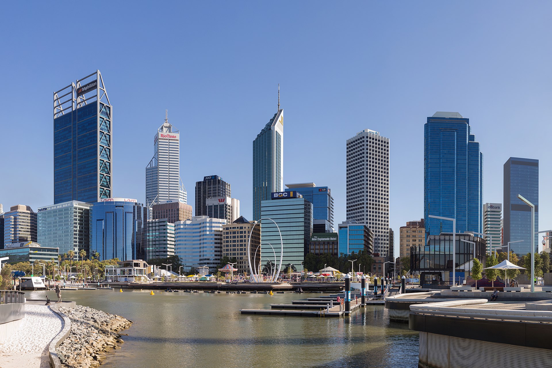
Perth anchors Western Australia with a compact coastal urban core, deep mining-services economy, and exceptional solar resource. Perth is a oceania city of about 2.2M metro in Australia. On the composite city-intelligence score, Perth sits comfortably above the indexed median (82/100).

Image credit: Image: Samuel Wiki / Wikimedia Commons, CC BY 4.0
Composite profile
82/100
Read Perth as an isolated but high-amenity coastal capital where service quality and outdoor amenity balance housing pressure and drought-resilience priorities.
82/100
Composite directional score across affordability, air quality, clean energy, and resilience.
Exceptional
Among the strongest solar irradiance levels globally.
Very high
Coastal and natural amenity supports a strong quality of daily life.
The table is part of the initial server-rendered HTML and mirrors the key city score cards.
| Metric | Value | Context |
|---|---|---|
| Overall score | 82/100 | Composite score across major city intelligence modules. |
| Cost of Living | 64/100 | Perth is expensive for housing, with services costs in line with major Australian peers. |
| Air Quality | 86/100 | Perth performs well against health-oriented air-quality benchmarks, with bushfire smoke the seasonal concern. |
| Energy | 78/100 | Perth benefits from exceptional solar resource and active grid modernization with high household solar adoption. |
| Safety | 88/100 | Perth scores well on safety, with stable institutional response and steady public-safety perception. |
| Internet Speed | 80/100 | Perth offers reliable fiber and mobile networks supporting digital services and remote work. |
| Climate Risk | 70/100 | Perth carries elevated climate risk centered on drought, bushfire, and rising heat. |
| Resilience | 76/100 | Climate adaptation and infrastructure continuity context. |
Deterministic safety estimates from our index — planning signals derived from country priors and city data, not official crime statistics.
Perth is estimated to be a generally safe city (77/100 in our safety index), with solid personal-safety indicators.
A composite quality-of-life estimate and its component indicators.
Perth has a very high quality-of-life estimate (85/100), with notable strengths in healthcare, green space, cleanliness and infrastructure.
How the city scores for raising a family, with the indicators that drive it.
Perth scores very high for family living (82/100), helped by education access, safety, parks and green space and healthcare.
Suitability for remote workers, based on connectivity, mobility, and livability.
Perth is high for remote workers (78/100), based on connectivity, affordability, walkability, safety and overall livability and day-to-day amenities.
Suitability for retirement, weighing healthcare, affordability, climate, and environment.
Perth is very high for retirement (82/100), appealing for healthcare access, affordability, a comfortable climate and a clean environment.
Local public safety guidance for Perth, with the country-level emergency contacts that apply when calling for police, fire, or ambulance.
| Service | Number | Notes |
|---|---|---|
| Universal emergency (Triple Zero) | 00024/7 | 000 reaches police, fire, and ambulance dispatch nationally; 112 also works from mobile phones. |
For the universal emergency contacts that apply in Perth, including police, fire, and ambulance, see the Australia emergency profile.
Each emergency contact above is attributed to an official emergency service or government publisher. Confirm current numbers directly with these sources.
Used as the primary attribution for Australia's 000 universal emergency number.
Last verified: 2026-05-16
Methodology and the wider source registry are documented on the scoring methodology and data sources pages.
Healthcare context for Perth, with national-level information from Australia where city-specific data is not yet verified. This is informational only and does not provide medical advice.
For the national healthcare and public-health context that applies in Perth, see the Australia healthcare profile.
Official hospital registry
MyHospitals — Australian Institute of Health and Welfare
Official Australian Government statistical agency portal with hospital information across the country.
Last verified: 2026-05-16
Each entry above is attributed to an official government, public health, or recognised health-system publisher. Confirm current information directly with these sources.
Used as the primary federal attribution for Australian public-health context.
Used as the official Australian hospital registry reference for verified facility lookups.
Last verified: 2026-05-16
Related sections: emergency and public safety, scoring methodology, and data sources.
Local mobility context for Perth, with national-level context from Australia where city-specific data is not yet verified. This is informational only.
For national transport authorities and operators that apply in Perth, see the Australia transport profile.
Each entry above is attributed to an official transport authority, national operator, airport publisher, or government source. Confirm current information directly with these publishers.
Used as the primary federal attribution for Australian national transport context.
Used as the primary attribution for Australian aviation authority information.
Last verified: 2026-05-16
Related sections: emergency and public safety, healthcare and hospitals, cities directory, countries directory, scoring methodology, data sources.
Source-attributed air-quality dataset for Perth. Verified measurements are surfaced when published from accepted official datasets; transparent fallback is shown otherwise.
Source-attributed values for Perth will appear here after the platform integrates verified measurements from accepted official publishers. Until then, structured air-quality module context remains available on the dedicated module page.
| Metric | Value | Data year | Status |
|---|---|---|---|
| Air quality | Verified air-quality measurements are not yet published for this location. | ||
Global City Intelligence — air-quality dataset
Verified data unavailableThe air-quality dataset begins empty by design. Verified city-level measurements appear here only after they are sourced from accepted publishers (WHO, EEA, US EPA, OpenAQ, OECD, or official national/city environmental agencies).
Numeric measurements appear in this section only after they are sourced from accepted official publishers. The dataset is independently validated at build time; malformed records cannot ship to production.
Quick, evidence-based answers about Perth drawn from this profile's indexed cost, climate, safety, economy, education, healthcare and nearby-nature data. Figures are deterministic estimates for orientation — verify specifics with official sources.
Yes — excellent quality of life (85/100), with nearby nature such as Rottnest Island, John Forrest National Park.
Excellent (82/100) on safety, schools and green space.
More affordable than average; about A$2,840/month for one person (estimate).
Late spring to early autumn; warmest in Jan, coldest in Jul.
Mainly tourism, technology, hospitality.
A mediterranean climate, averaging about 20.7°C.
Higher education is strong (78/100).
Healthcare access is strong (76/100).
Retirement suitability is strong (76/100).
Within ~170 km: Rottnest Island, John Forrest National Park.
Pairs that share a city, comparison intent, or region — useful for users planning a wider relocation, remote-work, or business decision.
City pages link to module and ranking pages so crawlers can move through the topic cluster naturally.
Perth is expensive for housing, with services costs in line with major Australian peers.
Perth performs well against health-oriented air-quality benchmarks, with bushfire smoke the seasonal concern.
Perth benefits from exceptional solar resource and active grid modernization with high household solar adoption.
Perth scores well on safety, with stable institutional response and steady public-safety perception.
Perth offers reliable fiber and mobile networks supporting digital services and remote work.
Perth carries elevated climate risk centered on drought, bushfire, and rising heat.
Compare this city against other indexed cities in crawlable ranking tables.
Cost of living estimates for Perth — monthly budgets, rent, food, and transport in the local currency, plus an affordability score for comparison. Planning estimates derived from country baselines, not live prices.
Climate profile for Perth — Mediterranean climate, annual average 20.7°C, comfort score 94/100. Month-by-month temperatures, rainfall, sunshine, and the best months to visit. Deterministic planning estimates, not a forecast.
Economy and jobs profile for Perth — major economy, economy score 80/100, key industries including tourism, technology, hospitality. Employment, salary, startup, remote-work, and career indicators. Deterministic planning estimates.
Education profile for Perth — major university city, education score 76/100, 9 representative universities, plus research, student life, and international-student indicators. Deterministic dataset, not institutional rankings.
Healthcare and retirement profile for Perth — major healthcare center, healthcare score 76/100, retirement score 76/100. Medical access, specialist and emergency care, affordability, and retirement suitability. Deterministic planning estimates.
Practical arrival planning context for Perth — links into transport, public-safety, healthcare, budgeting tools, and methodology. Not an official airport or travel instruction service.
Source-attributed visual context for Perth using verified Wikimedia imagery from the existing media catalog, alongside structured city intelligence and planning links. Not a tourism guide or attractions ranking.
Summer 2026 travel planning checklist for Perth — links into arrival planning, visual orientation, budget tools, transport, public safety, and healthcare context. Not a weather forecast, events calendar, hotel-price guide, or tourism ranking.
Weekend trip planning checklist for Perth — links into arrival planning, Summer 2026 travel context, visual orientation, budget tools, transport, public safety, and healthcare context. Not an itinerary, events calendar, hotel-price guide, restaurant guide, or tourism ranking.
Source-backed nearby place records for local-first weekend planning, with verification status, official source links, Wikidata identity, and visual context.
Estimate a monthly budget for Perth using your own housing, food, transport, healthcare, and lifestyle inputs. Planning estimator only — not an official cost-of-living measurement.
Plan a trip budget for Perth using your own accommodation, food, local transport, activities, travel, healthcare buffer, and emergency buffer inputs. Planning estimator only — not an official travel cost estimate.
Where else nearby you could spend a day or a weekend from Perth. Links are derived from geographic proximity, shared region, shared natural-recreation areas, transport corridors, and country borders — not popularity or tourism rankings.
Coastal cluster · about 154 km from Perth. Explore Bunbury's city intelligence profile.
Weekend trip · about 373 km from Perth. Explore Geraldton's city intelligence profile.
Same region · about 549 km from Perth. Explore Kalgoorlie's city intelligence profile.
Regional discovery collections that include Perth — named natural regions grouping nearby nature, parks, lakes, coasts, and mountains for local-first day and weekend planning.
Island region · 5 places across 35 cities.
National parks · 30 places across 80 cities.
Weekend escapes · 6 places across 5 cities.
Theme-first discovery collections that include Perth — grouped by outdoor interest (mountains, lakes, coasts, forests, national parks) rather than geography.
Hiking Areas · 50 places across 78 cities.
National Park Weekends · 50 places across 80 cities.
Nature Photography Spots · 34 places across 78 cities.
Weekend Nature Retreats · 50 places across 77 cities.
Hiking Areas · 50 places across 77 cities.
Nature Photography Spots · 50 places across 77 cities.
Common questions about living in, visiting, working in, studying in and retiring to Perth, answered from the indexed cost-of-living, climate, safety, economy, education, healthcare and nearby-nature data on this profile.
Perth has a very high quality-of-life estimate (85/100), with notable strengths in healthcare, green space, cleanliness and infrastructure. Visitors can also reach nature such as Rottnest Island, John Forrest National Park and Walyunga National Park within weekend range.
Perth has a very high quality-of-life estimate (85/100), with notable strengths in healthcare, green space, cleanliness and infrastructure. It indexes 85/100 for overall quality of life.
A single resident of Perth spends roughly A$2,840 per month, with a one-bedroom rent near A$1,510. Overall the city is more affordable than average for Australia. These are modelled estimates, not live quotes — verify locally.
Plan for below-average living costs and check current rents before relocating. Perth is high for remote workers (78/100), based on connectivity, affordability, walkability, safety and overall livability and day-to-day amenities.
Perth's labour market is very strong, with opportunities concentrated in technology, tourism and hospitality and education and research. Perth has a large and diversified economy with strengths in tourism, technology and hospitality.
Perth offers strong infrastructure and amenities for remote professionals, with a remote-work score of 82/100.
Perth is a major university city with a mix of universities and research activity in our dataset, spanning fields such as Social Sciences, Tourism and Engineering.
Perth offers a strong student environment, supported by walkable neighborhoods, relatively affordable living and strong quality of life.
Perth has a major healthcare center, supported by hospitals, specialist services, and public-health infrastructure, with a healthcare score of 76/100. Residents have very strong access to healthcare across primary, specialist, and emergency care.
Perth offers a combination of healthcare access, safety, and amenities that may appeal to retirees, with a retirement score of 76/100. Residents benefit from parks and green space, walkable streets and broad urban amenities and day-to-day services.
Perth has a mediterranean climate, averaging about 20.7°C annually with roughly 549 mm of rain. The hottest month is Jan and the coldest Jul. The driest is typically Jan.
Perth is estimated to be a generally safe city (77/100 in our safety index), with solid personal-safety indicators.
Perth indexes a walkability score of 73 and a cycling score of 69 out of 100. Check the local operator for live transit routes and fares.
Nature destinations within about 170 km of Perth include Rottnest Island, John Forrest National Park and Walyunga National Park. Each is linked with its official source on the profile.
Perth scores very high for family living (82/100), helped by education access, safety, parks and green space and healthcare.
Perth rates 62/100 for outdoor lifestyle and 82/100 for green space. Nearby nature such as Rottnest Island, John Forrest National Park and Walyunga National Park supports day hikes, water activities and weekend trips.
Read Perth as an isolated but high-amenity coastal capital where service quality and outdoor amenity balance housing pressure and drought-resilience priorities. Its standout dimensions are safety (88/100) and air quality (86/100). The area most worth watching is cost of living (64/100), where the model registers practical gaps. Data year 2025; last updated 2026-05-16. Drawn from 4 institutional references.
Country context is available on the Australia country page. Related rankings include Overall Intelligence, Quality of Life, Remote Work. See where Perth appears in global rankings or read the scoring methodology.
Structured indicators on this page are directional and intended for orientation. Verified datasets are being integrated; official sources should be used for critical decisions.
4 institutional references inform this view, listed below with reliability notes. Structured indicators on this page are directional and intended for orientation; verified datasets are being integrated and official sources should be used for critical decisions.
Used as a policy and methodology reference for urban exposure and resilience signals.
Used as an energy-resource and weather-normalization reference.
Used to explain urban climate vulnerability and adaptation scoring logic.
Used to ground energy-readiness scoring in international transition guidance.