Global CityIntelligence

Verified Wikimedia Commons image of Downie's Loup
Downie's Loupabout 9 km (6 mi) from Stirling. Image credit: Image: Andrew Smith / Wikimedia Commons, CC BY-SA 2.0

Nature discovery

Nature Near Stirling, United Kingdom

Research 18 classified outdoor destinations within weekend reach of Stirling, grouped across 7 kinds of place and ordered by measured straight-line distance from the city centre. Distances only — no travel times, schedules, or rankings.

Places listed
18
Closest
Downie's Loup — about 9 km
Furthest listed
about 54 km
Last updated
2026-05-16
Data year
2025

How this list is built

Each place is classified from its own Wikidata type, not from its name, and is ordered by measured straight-line distance from the centre of Stirling. Distances are great-circle kilometres between two published coordinates — this page does not publish travel times, transport schedules, opening hours, ticket prices, or rankings. Confirm access, facilities, and seasonal conditions with an official source before travelling.

How far these are

Reachability is a second axis over the same places: the category says what a destination is, the band says how far it sits from Stirling. Distances are measured in a straight line — this page publishes no travel times.

  • 18nearby

What is out there

  • 5forests
  • 5waterfalls
  • 4mountains
  • 1lake
  • 1national park
  • 1valley
  • 1wetland

18 places near Stirling

Ordered by straight-line distance from Stirling, closest first. Distance bands: nearby is up to 60 km.

Places near Stirling

Showing all 18 places.

  • Verified Wikimedia Commons image of Downie's Loup
    WaterfallNearby

    Downie's Loup

    Straight-line distance
    about 9 km (6 mi)
    Recorded type
    waterfall

    Downie's Loup is a waterfall reachable from Stirling as a nearby nature destination. Research access, facilities, and seasonal conditions with official sources before visiting.

    View place Downie's Loup, about 9 km (6 mi) from Stirling

    Image credit: Image: Andrew Smith / Wikimedia Commons, CC BY-SA 2.0

  • Verified Wikimedia Commons image of Loup of Fintry
    WaterfallNearby

    Loup of Fintry

    Straight-line distance
    about 15 km (9 mi)
    Recorded type
    waterfall

    Loup of Fintry is a waterfall reachable from Stirling as a nearby nature destination. Research access, facilities, and seasonal conditions with official sources before visiting.

    View place Loup of Fintry, about 15 km (9 mi) from Stirling

    Image credit: Image: Andrewmckie / Wikimedia Commons, CC BY-SA 4.0

  • Verified Wikimedia Commons image of Peggie's Spout
    WaterfallNearby

    Peggie's Spout

    Straight-line distance
    about 16 km (10 mi)
    Recorded type
    waterfall

    Peggie's Spout is a waterfall reachable from Stirling as a nearby nature destination. Research access, facilities, and seasonal conditions with official sources before visiting.

    View place Peggie's Spout, about 16 km (10 mi) from Stirling

    Image credit: Image: Robert Murray / Wikimedia Commons, CC BY-SA 2.0

  • Verified Wikimedia Commons image of Bracklinn Falls
    WaterfallNearby

    Bracklinn Falls

    Straight-line distance
    about 21 km (13 mi)
    Recorded type
    waterfall

    Bracklinn Falls is a waterfall reachable from Stirling as a nearby nature destination. Research access, facilities, and seasonal conditions with official sources before visiting.

    View place Bracklinn Falls, about 21 km (13 mi) from Stirling

    Image credit: Image: Sarah Charlesworth / Wikimedia Commons, CC BY-SA 2.0

  • Verified Wikimedia Commons image of Cauldron Linn
    WaterfallNearby

    Cauldron Linn

    Straight-line distance
    about 21 km (13 mi)
    Recorded type
    waterfall

    Cauldron Linn is a waterfall reachable from Stirling as a nearby nature destination. Research access, facilities, and seasonal conditions with official sources before visiting.

    View place Cauldron Linn, about 21 km (13 mi) from Stirling

    Image credit: Image: Iain McDonald / Wikimedia Commons, CC BY-SA 2.0

  • Verified Wikimedia Commons image of Ochil Hills
    MountainNearby

    Ochil Hills

    Straight-line distance
    about 22 km (14 mi)
    Recorded type
    mountain range

    Ochil Hills is Range of grassy escarpment hills rising directly northeast of Stirling above the Forth valley; highest point Ben Cleuch (). Research access, facilities, and seasonal conditions with official sources before visiting.

    View place Ochil Hills, about 22 km (14 mi) from Stirling

    Image credit: Image: The original uploader was Hellinterface at English Wikipedia. / Wikimedia Commons, CC BY-SA 3.0

  • Verified Wikimedia Commons image of Ben Ledi
    MountainNearby

    Ben Ledi

    Straight-line distance
    about 29 km (18 mi)
    Recorded type
    mountain

    Ben Ledi is Corbett mountain () in the Trossachs, northwest of Stirling near Callander. Research access, facilities, and seasonal conditions with official sources before visiting.

    View place Ben Ledi, about 29 km (18 mi) from Stirling

    Image credit: Image: Ian Cleland / Wikimedia Commons, CC BY-SA 2.0

  • Verified Wikimedia Commons image of Loch Lubnaig
    LakeNearby

    Loch Lubnaig

    Straight-line distance
    about 30 km (18 mi)
    Recorded type
    lake

    Loch Lubnaig is Freshwater loch near Callander, northwest of Stirling, between Ben Ledi and Ben Vorlich. Research access, facilities, and seasonal conditions with official sources before visiting.

    View place Loch Lubnaig, about 30 km (18 mi) from Stirling

    Image credit: Image: Original uploader was Grinnerat en.wikipedia / Wikimedia Commons, CC BY-SA 3.0

  • Verified Wikimedia Commons image of The Trossachs
    ValleyNearby

    The Trossachs

    Straight-line distance
    about 33 km (20 mi)
    Recorded type
    glen

    The Trossachs is Region of wooded glens, braes and lochs in the southern Highlands, northwest of Stirling near Callander and Aberfoyle. Research access, facilities, and seasonal conditions with official sources before visiting.

    View place The Trossachs, about 33 km (20 mi) from Stirling

    Image credit: Image: David Monniaux / Wikimedia Commons, CC BY-SA 3.0

  • Verified Wikimedia Commons image of Ben A'an
    MountainNearby

    Ben A'an

    Straight-line distance
    about 33 km (21 mi)
    Recorded type
    hill

    Ben A'an is Small rocky hill () above Loch Katrine in the Trossachs, northwest of Stirling. Research access, facilities, and seasonal conditions with official sources before visiting.

    View place Ben A'an, about 33 km (21 mi) from Stirling

    Image credit: Image: Bermicourt / Wikimedia Commons, CC BY-SA 4.0

  • Verified Wikimedia Commons image of Ben Lomond
    MountainNearby

    Ben Lomond

    Straight-line distance
    about 44 km (27 mi)
    Recorded type
    mountain

    Ben Lomond is Munro () on the eastern shore of Loch Lomond, west of Stirling, the most southerly Munro. Research access, facilities, and seasonal conditions with official sources before visiting.

    View place Ben Lomond, about 44 km (27 mi) from Stirling

    Image credit: Image: Fingalo / Wikimedia Commons, CC BY-SA 2.0 de
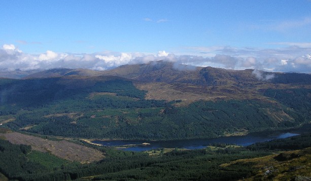
  • Verified Wikimedia Commons image of Loch Lomond and The Trossachs National Park
    National parkNearby

    Loch Lomond and The Trossachs National Park

    Straight-line distance
    about 45 km (28 mi)
    Recorded type
    national park of Scotland

    Loch Lomond and The Trossachs National Park is National park of lochs, hills and glens immediately west and northwest of Stirling, the nearest national park. Research access, facilities, and seasonal conditions with official sources before visiting.

    View place Loch Lomond and The Trossachs National Park, about 45 km (28 mi) from Stirling

    Image credit: Image: Postdlf / Wikimedia Commons, CC BY-SA 3.0

  • Verified Wikimedia Commons image of Hawkhill Wood
    ForestNearby

    Hawkhill Wood

    Straight-line distance
    about 54 km (33 mi)
    Recorded type
    forest

    Hawkhill Wood is a forest reachable from Stirling as a nearby nature destination. Research access, facilities, and seasonal conditions with official sources before visiting.

    View place Hawkhill Wood, about 54 km (33 mi) from Stirling

    Image credit: Image: Richard Webb / Wikimedia Commons, CC BY-SA 2.0