Global CityIntelligence

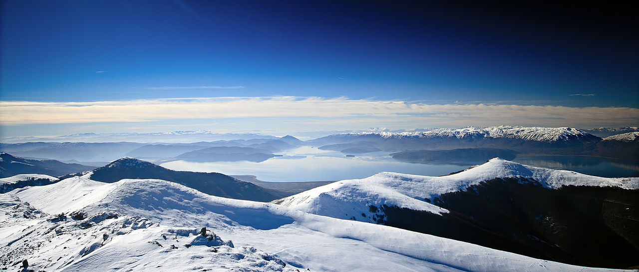
Verified Wikimedia Commons image of Lake Ohrid
Lake Ohridabout 12 km (7 mi) from Ohrid. Image credit: Image: Krisaemilia / Wikimedia Commons, CC BY-SA 3.0

Nature discovery

Nature Near Ohrid, North Macedonia

Research 13 classified outdoor destinations within weekend reach of Ohrid, grouped across 6 kinds of place and ordered by measured straight-line distance from the city centre. Distances only — no travel times, schedules, or rankings.

Places listed
13
Closest
Lake Ohrid — about 12 km
Furthest listed
about 112 km
Last updated
2026-05-16
Data year
2025

How this list is built

Each place is classified from its own Wikidata type, not from its name, and is ordered by measured straight-line distance from the centre of Ohrid. Distances are great-circle kilometres between two published coordinates — this page does not publish travel times, transport schedules, opening hours, ticket prices, or rankings. Confirm access, facilities, and seasonal conditions with an official source before travelling.

How far these are

Reachability is a second axis over the same places: the category says what a destination is, the band says how far it sits from Ohrid. Distances are measured in a straight line — this page publishes no travel times.

  • 9nearby
  • 4day-trip distance

What is out there

  • 5waterfalls
  • 3national parks
  • 2mountains
  • 2protected areas
  • 1lake
  • 1river

13 places near Ohrid

Ordered by straight-line distance from Ohrid, closest first. Distance bands: nearby is up to 60 km, day-trip distance is up to 120 km.

Places near Ohrid

Showing all 13 places.

  • Verified Wikimedia Commons image of Lake Ohrid
    LakeNearby

    Lake Ohrid

    Straight-line distance
    about 12 km (7 mi)
    Recorded type
    lake

    Lake Ohrid is Ancient tectonic lake on the North Macedonia–Albania border; the town of Ohrid sits on its northeastern shore. Research access, facilities, and seasonal conditions with official sources before visiting.

    View place Lake Ohrid, about 12 km (7 mi) from Ohrid

    Image credit: Image: Krisaemilia / Wikimedia Commons, CC BY-SA 3.0

  • Verified Wikimedia Commons image of Black Drin
    RiverNearby

    Black Drin

    Straight-line distance
    about 12 km (8 mi)
    Recorded type
    river

    Black Drin is River that flows out of Lake Ohrid at Struga, nearby north of Ohrid, running north and west toward Albania. Research access, facilities, and seasonal conditions with official sources before visiting.

    View place Black Drin, about 12 km (8 mi) from Ohrid

    Image credit: Image: Eqerem Karaj / Wikimedia Commons, CC BY-SA 4.0

  • Verified Wikimedia Commons image of Ohrid-Prespa Transboundary Biosphere Reserve
    Protected areaNearby

    Ohrid-Prespa Transboundary Biosphere Reserve

    Straight-line distance
    about 15 km (9 mi)
    Recorded type
    biosphere reserve

    Ohrid-Prespa Transboundary Biosphere Reserve is UNESCO-designated cross-border protected landscape spanning the Ohrid and Prespa lake basins around Ohrid. Research access, facilities, and seasonal conditions with official sources before visiting.

    View place Ohrid-Prespa Transboundary Biosphere Reserve, about 15 km (9 mi) from Ohrid

    Image credit: Image: Darkocv / Wikimedia Commons, CC BY-SA 3.0

  • Verified Wikimedia Commons image of Galičica National Park
    MountainNearby

    Galičica National Park

    Straight-line distance
    about 20 km (12 mi)
    Recorded type
    mountain range

    Galičica National Park is National park on a karst mountain ridge directly east of Ohrid, between Lake Ohrid and Lake Prespa, rising to about . Research access, facilities, and seasonal conditions with official sources before visiting.

    View place Galičica National Park, about 20 km (12 mi) from Ohrid

    Image credit: Image: Krisaemilia / Wikimedia Commons, CC BY-SA 3.0

  • Verified Wikimedia Commons image of Jablanica
    MountainNearby

    Jablanica

    Straight-line distance
    about 29 km (18 mi)
    Recorded type
    mountain

    Jablanica is Karst mountain range on the North Macedonia–Albania border northwest of Ohrid, above Struga, reaching about . Research access, facilities, and seasonal conditions with official sources before visiting.

    View place Jablanica, about 29 km (18 mi) from Ohrid

    Image credit: Image: Alan Grant / Wikimedia Commons, CC BY-SA 3.0

  • Verified Wikimedia Commons image of Shebenik-Jabllanicë National Park
    National parkNearby

    Shebenik-Jabllanicë National Park

    Straight-line distance
    about 32 km (20 mi)
    Recorded type
    national park

    Shebenik-Jabllanicë National Park is National park on the Albanian side of the border northwest of Lake Ohrid, with glacial lakes and beech forests. Research access, facilities, and seasonal conditions with official sources before visiting.

    View place Shebenik-Jabllanicë National Park, about 32 km (20 mi) from Ohrid

    Image credit: Image: Spyenson / Wikimedia Commons, CC BY-SA 3.0
  • Verified Wikimedia Commons image of Pelister National Park
    National parkNearby

    Pelister National Park

    Straight-line distance
    about 36 km (22 mi)
    Recorded type
    national park

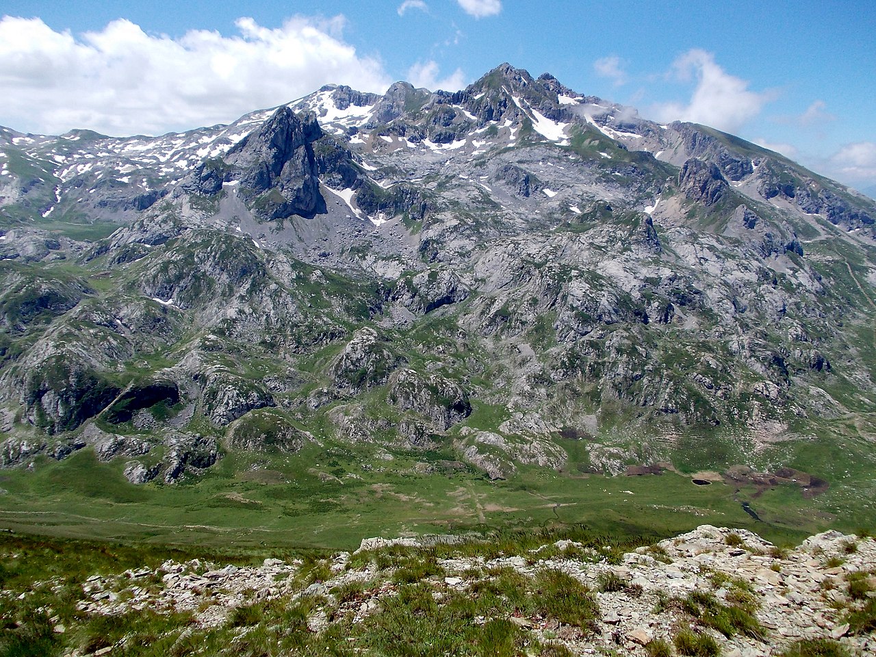
    Pelister National Park is National park on the Baba Mountain massif east-southeast of Ohrid near Bitola, with peaks above and two glacial lakes. Research access, facilities, and seasonal conditions with official sources before visiting.

    View place Pelister National Park, about 36 km (22 mi) from Ohrid

    Image credit: Image: MartinDimitrievski / Wikimedia Commons, CC BY-SA 3.0

  • Verified Wikimedia Commons image of Duf Falls
    WaterfallNearby

    Duf Falls

    Straight-line distance
    about 57 km (35 mi)
    Recorded type
    waterfall

    Duf Falls is a waterfall reachable from Ohrid as a nearby nature destination. Research access, facilities, and seasonal conditions with official sources before visiting.

    View place Duf Falls, about 57 km (35 mi) from Ohrid

    Image credit: Image: Kiril Simeonovski / Wikimedia Commons, CC BY-SA 4.0

  • Verified Wikimedia Commons image of Mavrovo National Park
    National parkNearby

    Mavrovo National Park

    Straight-line distance
    about 59 km (37 mi)
    Recorded type
    national park

    Mavrovo National Park is Large national park north of Ohrid in western North Macedonia, covering the Bistra, Korab and Šar mountain systems and the Radika valley. Research access, facilities, and seasonal conditions with official sources before visiting.

    View place Mavrovo National Park, about 59 km (37 mi) from Ohrid

    Image credit: Image: Pavouk / Wikimedia Commons, CC BY-SA 3.0

  • Verified Wikimedia Commons image of Korab Falls
    WaterfallDay-trip distance

    Korab Falls

    Straight-line distance
    about 75 km (47 mi)
    Recorded type
    waterfall

    Korab Falls is a waterfall reachable from Ohrid as a nearby nature destination. Research access, facilities, and seasonal conditions with official sources before visiting.

    View place Korab Falls, about 75 km (47 mi) from Ohrid

    Image credit: Image: Martinn / Wikimedia Commons, CC BY-SA 3.0