Nearby Weekend Places from Ponta Delgada, Portugal
Research source-backed public places within weekend reach of Ponta Delgada. The records on this page are planning candidates — not a route planner, not a tourism ranking, not a live schedule, and not a price guide. Verify access, transport, weather, opening status, and seasonal conditions with the official source linked on each record before departure.
This page helps users research nearby weekend places connected to Ponta Delgada, Portugal, as a starting point for local-first weekend rest. It is not a route planner, ticket guide, events page, tourism ranking, or live availability source. Records are planning candidates only.
Records do not publish exact distances, travel times, transport schedules, opening hours, ticket prices, restaurant or hotel recommendations, attraction rankings, or live access status. Confirm time-sensitive details with the official park, museum, transport authority, or municipal source linked on each record.
Each card opens an official source where Wikidata lists one, plus links to the connected city, country profile, and the detail page for verified records. Records are unordered and not ranked; verify access and conditions with the official source before departure.
Agua de Pau Massif is Stratovolcanic massif occupying central Sao Miguel and containing Lagoa do Fogo, nearby east of Ponta Delgada. Research access, facilities, and seasonal conditions with official sources before visiting.
Furnas is Volcanic caldera with a crater lake, fumaroles and hot springs in the southeast of Sao Miguel, nearby east of Ponta Delgada. Research access, facilities, and seasonal conditions with official sources before visiting.
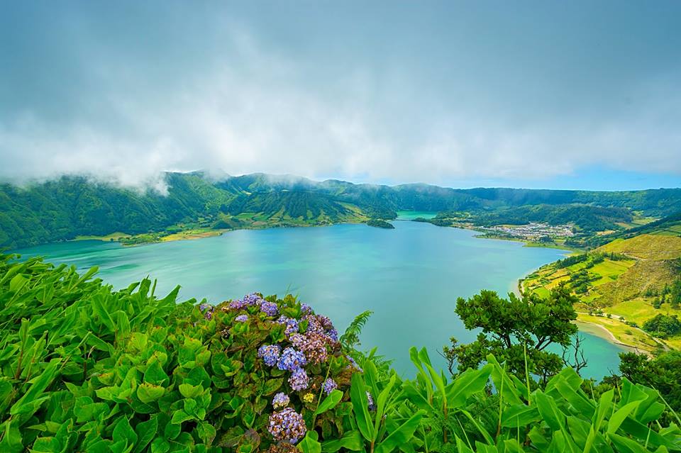
Lagoa do Fogo is Protected crater lake in the central caldera of the Agua de Pau Massif, nearby east of Ponta Delgada in the centre of Sao Miguel. Research access, facilities, and seasonal conditions with official sources before visiting.
Mosteiros Islets is Four uninhabited volcanic rock islets off the northwest coast of Sao Miguel near Mosteiros, nearby northwest of Ponta Delgada. Research access, facilities, and seasonal conditions with official sources before visiting.
Pico da Vara is Highest peak of Sao Miguel () in the Serra da Tronqueira, with the island's largest laurisilva forest reserve, nearby east of Ponta Delgada. Research access, facilities, and seasonal conditions with official sources before visiting.
Sete Cidades Lakes is Twin crater lakes (blue and green) inside the Sete Cidades caldera at the western end of Sao Miguel, about 20-nearby west-northwest of Ponta Delgada. Research access, facilities, and seasonal conditions with official sources before visiting.
Sete Cidades Massif is Stratovolcanic complex and large caldera forming the western end of Sao Miguel, nearby west of Ponta Delgada. Research access, facilities, and seasonal conditions with official sources before visiting.
Vila Franca Islet is Uninhabited tuff-cone islet and nature reserve with a circular crater lagoon off the south coast, nearby east of Ponta Delgada. Research access, facilities, and seasonal conditions with official sources before visiting.
This page is a planning surface. Records do not publish exact distances, travel times, transport schedules, opening hours, ticket prices, restaurant or hotel recommendations, attraction rankings, or live access status.
Start with the Ponta Delgada city profile to anchor the location and country context.
Compare the nearby place records above against your origin city’s transport and access patterns.
Open the detail page for any record marked “Verified source record” to see the official source, Wikidata identity, and visual context.
Check the official source linked on each record for current opening, access, seasonal status, and conditions before departure.
Use the travel budget calculator for user-entered estimates — the platform does not publish ticket prices, transport schedules, or hotel/flight prices.
Confirm route, weather, opening/access status, and costs from official or trusted current sources before departure.
Verification status legend
The status shown on each card reflects the level of source verification: a matched Wikidata identity together with an official URL is shown as verified, an identity match without a confirmed official URL is shown as partially verified, and records not yet matched to a stable identifier are shown as pending review.
Partially verified source record
8
Sources and methodology
Nearby weekend places are sourced exclusively from Wikidata — primary identifier (QID), coordinates (P625), and official website (P856) — together with the linked operator (park authority, municipality, heritage body, or UNESCO official page) where Wikidata’s P856 points at it. Records do not publish fixed itineraries, attraction rankings, restaurant or hotel recommendations, event or festival dates, ticket prices, hotel or flight prices, opening hours, transport schedules, exact travel times, exact distances, weather forecasts, crime rates, or any “best” / “must-see” / “safest” / “cheapest” claims. Verify access, opening times, weather, health, and safety details with the official source linked on each record before departure. Read the scoring methodology for how structured indicators are constructed, and the data sources registry for the official publishers cited across the platform.
Continue exploring
Open related platform layers behind Ponta Delgada weekend research. Verify events, opening hours, transport, weather, health, and safety details with official or trusted current sources before departure.