Nearby Weekend Places from Murfreesboro, United States
Research source-backed public places within weekend reach of Murfreesboro. The records on this page are planning candidates — not a route planner, not a tourism ranking, not a live schedule, and not a price guide. Verify access, transport, weather, opening status, and seasonal conditions with the official source linked on each record before departure.
This page helps users research nearby weekend places connected to Murfreesboro, United States, as a starting point for local-first weekend rest. It is not a route planner, ticket guide, events page, tourism ranking, or live availability source. Records are planning candidates only.
Records do not publish exact distances, travel times, transport schedules, opening hours, ticket prices, restaurant or hotel recommendations, attraction rankings, or live access status. Confirm time-sensitive details with the official park, museum, transport authority, or municipal source linked on each record.
Each card opens an official source where Wikidata lists one, plus links to the connected city, country profile, and the detail page for verified records. Records are unordered and not ranked; verify access and conditions with the official source before departure.
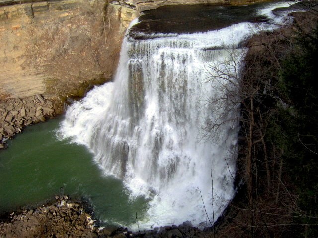
Burgess Falls State Park is Day-use park where the Falling Water River drops through a gorge in a series of falls including a cataract, nearby east of Murfreesboro. Research access, facilities, and seasonal conditions with official sources before visiting.
Cedars of Lebanon State Park is State park set in cedar-glade and limestone karst forest nearby north of Murfreesboro in Wilson County. Research access, facilities, and seasonal conditions with official sources before visiting.
Center Hill Lake is Reservoir on the Caney Fork River near Smithville, nearby east of Murfreesboro. Research access, facilities, and seasonal conditions with official sources before visiting.
Cummins Falls State Park is Park centered on a waterfall on the Blackburn Fork in a river gorge, northwest of Cookeville nearby northeast of Murfreesboro. Research access, facilities, and seasonal conditions with official sources before visiting.
J. Percy Priest Lake is Army Corps reservoir on the Stones River about 25-nearby northwest of Murfreesboro, spanning Rutherford, Davidson and Wilson counties. Research access, facilities, and seasonal conditions with official sources before visiting.
Old Stone Fort State Archaeological Park is Park on a peninsula at the confluence of the Duck and Little Duck rivers with gorges and waterfalls, near Manchester nearby southeast of Murfreesboro. Research access, facilities, and seasonal conditions with official sources before visiting.
Image: This image was created by user Brian Adamo (adamo588) at Mushroom Observer, a source for mycological images.You can contact this user here. / Wikimedia Commons, CC0. Visual context only.
Rock Island State Park is State park on the Caney Fork featuring the Great Falls Gorge and cascade waterfalls, nearby southeast of Murfreesboro on the Cumberland Plateau edge. Research access, facilities, and seasonal conditions with official sources before visiting.
Stones River is River of the Nashville Basin whose West Fork runs just west of downtown Murfreesboro; greenways and riparian woods along its banks. Research access, facilities, and seasonal conditions with official sources before visiting.
This page is a planning surface. Records do not publish exact distances, travel times, transport schedules, opening hours, ticket prices, restaurant or hotel recommendations, attraction rankings, or live access status.
Start with the Murfreesboro city profile to anchor the location and country context.
Compare the nearby place records above against your origin city’s transport and access patterns.
Open the detail page for any record marked “Verified source record” to see the official source, Wikidata identity, and visual context.
Check the official source linked on each record for current opening, access, seasonal status, and conditions before departure.
Use the travel budget calculator for user-entered estimates — the platform does not publish ticket prices, transport schedules, or hotel/flight prices.
Confirm route, weather, opening/access status, and costs from official or trusted current sources before departure.
Verification status legend
The status shown on each card reflects the level of source verification: a matched Wikidata identity together with an official URL is shown as verified, an identity match without a confirmed official URL is shown as partially verified, and records not yet matched to a stable identifier are shown as pending review.
Verified source record
4
Partially verified source record
4
Sources and methodology
Nearby weekend places are sourced exclusively from Wikidata — primary identifier (QID), coordinates (P625), and official website (P856) — together with the linked operator (park authority, municipality, heritage body, or UNESCO official page) where Wikidata’s P856 points at it. Records do not publish fixed itineraries, attraction rankings, restaurant or hotel recommendations, event or festival dates, ticket prices, hotel or flight prices, opening hours, transport schedules, exact travel times, exact distances, weather forecasts, crime rates, or any “best” / “must-see” / “safest” / “cheapest” claims. Verify access, opening times, weather, health, and safety details with the official source linked on each record before departure. Read the scoring methodology for how structured indicators are constructed, and the data sources registry for the official publishers cited across the platform.
Continue exploring
Open related platform layers behind Murfreesboro weekend research. Verify events, opening hours, transport, weather, health, and safety details with official or trusted current sources before departure.