Research source-backed public places within weekend reach of Bray. The records on this page are planning candidates — not a route planner, not a tourism ranking, not a live schedule, and not a price guide. Verify access, transport, weather, opening status, and seasonal conditions with the official source linked on each record before departure.
This page helps users research nearby weekend places connected to Bray, Ireland, as a starting point for local-first weekend rest. It is not a route planner, ticket guide, events page, tourism ranking, or live availability source. Records are planning candidates only.
Records do not publish exact distances, travel times, transport schedules, opening hours, ticket prices, restaurant or hotel recommendations, attraction rankings, or live access status. Confirm time-sensitive details with the official park, museum, transport authority, or municipal source linked on each record.
Each card opens an official source where Wikidata lists one, plus links to the connected city, country profile, and the detail page for verified records. Records are unordered and not ranked; verify access and conditions with the official source before departure.
Bray Head is coastal hill and headland on the Irish Sea immediately south of Bray town, between Bray and Greystones. Research access, facilities, and seasonal conditions with official sources before visiting.
Dalkey Island is Uninhabited island off the coast south of Dun Laoghaire, north of Bray near Dalkey. Research access, facilities, and seasonal conditions with official sources before visiting.
Djouce is mountain in the Wicklow Mountains, south-southwest of Bray near Roundwood. Research access, facilities, and seasonal conditions with official sources before visiting.
Great Sugar Loaf is conical quartzite peak in the northeastern Wicklow Mountains, nearby southwest of Bray above Kilmacanogue. Research access, facilities, and seasonal conditions with official sources before visiting.
Killiney Hill is hill and public park on the southern boundary of Dublin Bay, north of Bray near Dalkey. Research access, facilities, and seasonal conditions with official sources before visiting.
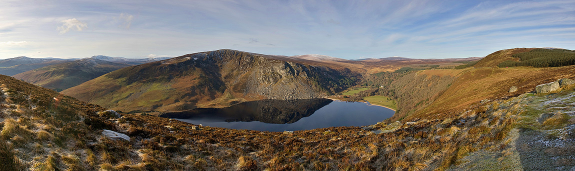
Lough Tay is Small lake set between Djouce and Luggala in the Wicklow Mountains, southwest of Bray. Research access, facilities, and seasonal conditions with official sources before visiting.
Powerscourt Waterfall is waterfall on the River Dargle near Enniskerry in County Wicklow, southwest of Bray. Research access, facilities, and seasonal conditions with official sources before visiting.
Wicklow Mountains National Park is 205 sq km national park covering the upland and moorland of the Wicklow Mountains south of Bray. Research access, facilities, and seasonal conditions with official sources before visiting.
This page is a planning surface. Records do not publish exact distances, travel times, transport schedules, opening hours, ticket prices, restaurant or hotel recommendations, attraction rankings, or live access status.
Start with the Bray city profile to anchor the location and country context.
Compare the nearby place records above against your origin city’s transport and access patterns.
Open the detail page for any record marked “Verified source record” to see the official source, Wikidata identity, and visual context.
Check the official source linked on each record for current opening, access, seasonal status, and conditions before departure.
Use the travel budget calculator for user-entered estimates — the platform does not publish ticket prices, transport schedules, or hotel/flight prices.
Confirm route, weather, opening/access status, and costs from official or trusted current sources before departure.
Verification status legend
The status shown on each card reflects the level of source verification: a matched Wikidata identity together with an official URL is shown as verified, an identity match without a confirmed official URL is shown as partially verified, and records not yet matched to a stable identifier are shown as pending review.
Verified source record
1
Partially verified source record
7
Sources and methodology
Nearby weekend places are sourced exclusively from Wikidata — primary identifier (QID), coordinates (P625), and official website (P856) — together with the linked operator (park authority, municipality, heritage body, or UNESCO official page) where Wikidata’s P856 points at it. Records do not publish fixed itineraries, attraction rankings, restaurant or hotel recommendations, event or festival dates, ticket prices, hotel or flight prices, opening hours, transport schedules, exact travel times, exact distances, weather forecasts, crime rates, or any “best” / “must-see” / “safest” / “cheapest” claims. Verify access, opening times, weather, health, and safety details with the official source linked on each record before departure. Read the scoring methodology for how structured indicators are constructed, and the data sources registry for the official publishers cited across the platform.
Continue exploring
Open related platform layers behind Bray weekend research. Verify events, opening hours, transport, weather, health, and safety details with official or trusted current sources before departure.